2. The names of the adjacent quadrangles are Gonoga Park, Van Nuys, Burbank, Topanga, Hollywood, Venice, and Inglewood.
3. The map was first created in 1966.
4. The horizontal datum used to compile this map was NAD 27, the vertical datum used is National Geodetic Vertical Datum of 1929.
5. The scale is 1:24000
6. a) D=24000cm x 5=1200 meters
b) D=24000in x 5 =1.894 miles
c) D=63360in/24000=2.64 ind) D= 300cm/24= 12.5 cm
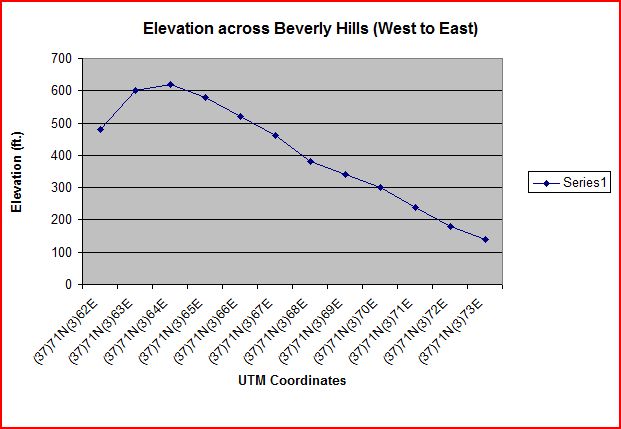
7. The contour interval is 20 ft.
8. a) The longitude is 118 deg 26' 58" and the latitude is 34 deg 4' 15". The decimal longitude is 118.449497 and the latitude is 34.071074.
b)The longitude is 118 deg 29' 52" and the latitude is 34 deg 00' 31". The decimal longitude is 118.4978 and the latitude is 34.0086
c)The longitude is 118 deg 24 ' 37" and the latitude is 34 deg 07' 10". The decimal longitude is 118.4102 and the latitude is 34.1194
9. a) The elevation is 560 ftb) The elevation is 140 ft
c) The elevation is 620 ft10. Zone 11
11. 3763000 meters North and 361500 meters East
12. There are 1,000,000 sq meters in each cell.
13.
 14. 14 deg
15.
 The intermittent stream is flowing from North to South
16.


No comments:
Post a Comment